Photos from a Hike Through the Grand Canyon
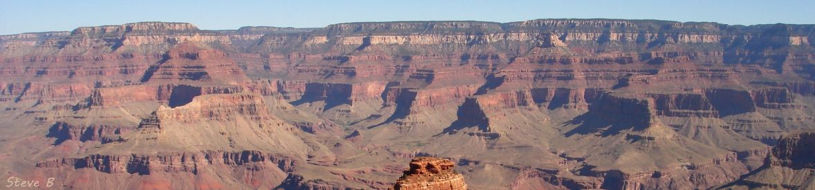
The banner photo is of the north rim of the Grand Canyon, a view from the South Kaibab Trail near its top on the south rim.
This article comes from a hike by some family members and friends.
Hiking through the Grand Canyon is a 3-day adventure! Day one is preparation - driving to North Rim Village to drop off the cars and taking the shuttle to South Rim Village; day two is hiking down the
South Kaibab Trail to Phantom Ranch or Bright Angel Campground on the canyon floor; day three is hiking up the North Kaibab trail to the North Rim Village.
From the NPS: DO NOT attempt to hike from the rim to the river and back in one day.
The hike begins on the open and photogenic South Kaibab Trail, 7 miles (11.3 km) long, dropping 4,780 feet (1,457 meters) into the canyon, crossing Kaibab Trail Bridge (black bridge
), arriving at Phantom Ranch on the canyon floor.
The hike continues up the North Kaibab trail, 14 miles (22.5 km) long, climbing 5,761 feet (1,756 meters) up narrow Bright Angel Canyon to North Rim Village at an elevation of 8,000+ feet (2,438+ meters).
The lodge and campground in the Village are open May 15 to September 15 - Arizona highway 67 to the North Rim is closed in winter due to the inability to keep the road open because of heavy snowfall.
There is a lot to do and see at this marvelous geologic wonder: Mary Colter's Lookout Studio, Desert View Watchtower, and Hopi House; the Kolb Studio that cascades down the side of the canyon, the Train Depot, and Verkamp's Visitor Center. There are a number of commercial trips through the Canyon. The South Kaibab and North Kaibab Trails have been designated as part of the Arizona National Scenic Trail, an 817-mile trail across the length of Arizona from Mexico to Utah (map on the menu).
Select On the Trail (not from Ferdê Grofe's Grand Canyon Suite !  ) for a gallery of photos of the trail shot during the hike.
Select Scenic Views for photos of the awesome scenery of the Grand Canyon that were taken along the trail and the shuttle trip.
Corridor Trails is a map of the three corridor trails, North Rim Map show the North Rim Village and the corridor trails, Arizona National Scenic Trail Map is a graphic of that trail, and Wide Area Map is a map of Grand Canyon with the surrounding highways.
Stratigraphy is the Three Sets of Rocks
graphic of the canyon's stratigraphy.
Lookout Studio, Watchower, and Hopi House are photos of historic buildings by master architect and interior designer Mary Elizabeth Jane Colter.
Kolb Studio was built in 1904 by the Kolb bothers and has been maintained by the NPS since their death.
And Trail Bridges is photos of the black and silver bridges from our Colorado River Bridges article.
There is an interesting Grand Canyon fly-over video at NPS, see it from our State and National Park Videos menu or at
 NPS.
NPS.