Bears Ears National Monument
The Bears Ears National Monument has two disjointed units - the Shash Jáa Unit and the Indian Creek Unit.
The area within the monument is largely undeveloped and contains a wide array of historic, cultural, and natural resources, and includes many hiking trails and campgrounds.
The Shash Jáa (Native American translation of Bears Ears
) Unit begins approximately 5 miles east of the Natural Bridges National Monument boundary with the Bears Ears buttes that provide the monument name, continues east to include Lower Mule Canyon, Comb Wash, Comb Ridge, and Butler Wash, then runs south all the way to the Utah/Navajo Nation boundary.
The Indian Creek Unit, to the north on the other side of the Manti-La Sal National Forest, begins at the eastern boundary of Canyonlands National Park (Needles District) and the Butler Wash Wilderness Study Area, and extends east for approximately 10 miles (the boundary slants to the southeast) and includes the Sixshooter peaks, Newspaper Rock, Bridger Jack Mesa and its WSA, and the Indian Creek corridor rock-climbing area.
It also includes Utah 211, the highway to the Needles District of Canyonlands and its visitors center, the map identifying it as the Indian Creek Scenic Backway
(it is a very scenic drive).
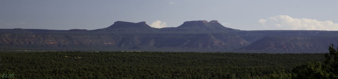
The monument is named for the pair of buttes shown in the banner photo that rise to elevations over 8,900 feet (2,700 m) and 9,000 feet (2,700 m), more than 2,000 feet (610 m) above the junction of Utah state roads 95 and 261. Capped by Wingate Sandstone, the buttes and surroundings have long been held as sacred or significant by a number of the region's Native American tribes. Ancestral Puebloan cliff dwellings dated to more than 3,500 years ago have been discovered in the region, just some of the estimated 100,000 archaeological sites protected within the monument. Cultural management areas within its boundaries include the Newspaper Rock Petroglyph Panel and the Butler Wash Archaeological District National Register.
The monument was established by President Barack Obama by presidential proclamation on December 28, 2016, claiming the Antiquities Act gave him the right to bypass Congress for its creation, as did Bill Clinton in creating the Grand Staircase-Escalante National Monument on September 18, 1996. Both monuments were reduced in size by proclamation by President Donald Trump on December 4, 2017, presumably because both were created as retribution for poor presidential election results in Utah for both presidents Clinton (who came in 3rd behind H. Ross Perot) and Obama.
The Indian Creek area is internationally renown for its Wingate sandstone walls - crack-climbing in the area is generally rated 5.10 - 5.12.
The Photo gallery includes scenic views in the monument and crack-climbing photos in the Indian Creek area with an auto-show of the photos.
The Bears Ears map shows the new monument boundaries - the Shash Jáa Unit is the red-shaded area on the north, the Indian Creek Unit is the blue-shaded area on the south.
The Road map was cut from the Utah state highway map - it does not identify the monument - Indian Creek Unit is at the top edge of the map, and the Bears Ears buttes are identified above U95 east of Natural Bridges National Monument (the banner photo).
The Climbing map identifies Main crags and access
to the many climbing walls in the canyons of the Indian Creek Unit.