Capitol Reef National Park
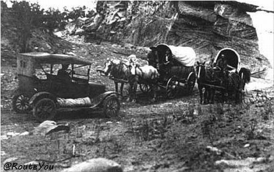
Capitol Reef National Monument was created by President Roosevelt in 1937 to protect the area's colorful canyons, ridges, buttes, and monoliths. This comprised an area extending about two miles (3 km) north of present Scenic Byway 24 (Utah State Route 24) and about 10 mi (16 km) south, just past Capitol Gorge. There were no roads in the area - a car cuts through the narrows of Capitol wash between Fruita and Notom in this 1935 photo; and an earlier photo on the Capitol Gorge wagon trail. Road access was provided in 1962 with the construction of State Route 24 through the Fremont River Canyon. Visitors started coming to the area so Congress made it a national park to preserve Waterpocket Fold.
Capitol Reef became a National Park in 1970. The park is roughly 6 miles (9.7 km) wide and 60 miles (96.7 km) long as it follows the Waterpocket Fold monocline until it reaches Glen Canyon NRA. Scenic Byway 24 cuts across the park on a scenic ride inside the Fremont River Canyon. The Burr Trail, unpaved inside the park, crosses the rugged fold on dirt switchbacks. Partially-paved Notom-Bullfrog Road runs alongside Waterpocket Fold, forming a scenic loop with the Burr Trail across the dirt switchbacks and up the scenic trail, Scenic Byway 12 over Boulder Mountain, and Scenic Byway 24 through Fremont River Canyon.
Capitol Reef
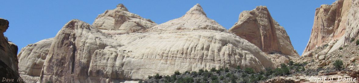
is the name of an especially rugged and spectacular segment of the Waterpocket Fold near the Fremont River, in the area where U24 crosses the Fold.
It is named for a line of white domes and cliffs of Navajo Sandstone, each of which looks somewhat like the United States Capitol building, that run from the Fremont River to Pleasant Creek on the Waterpocket Fold.
The Waterpocket Fold monocline is a buckle in the earth's surface, nearly 100 miles long, running north- south in the south-central Utah desert from Thousand Lake Mountain near Torrey, Utah, to Lake Powell in Glen Canyon National Recreation Area. It is the largest exposed monocline in North America. More information is available in the Waterpocket Fold article.
The area of Capitol Reef has been a homeland to people for thousands of years. Archaic hunters and gatherers migrated through the canyons. The Fremont Culture solidified around 500 AD. Many years after the Fremont left, Paiutes moved into the area. Members of the Church of Jesus Christ of Latter-day Saints settled the Fremont River valley in the 1880s and established Junction (later renamed Fruita). In addition to farming, lime was extracted from local limestone and uranium was extracted early in the 20th century.
Capitol Reef, Waterpocket Fold, and Scenic Byway 24 are integrally entwined, the Photo Gallery includes shared photos from all three. The gallery includes an auto-show of the photos. Capitol Reef Map is a resizable pdf map of Capitol Reef National Park from the NPS.
An in-depth discussion of Capitol Reef geology is available with the Wiki Geology menu selection.