History of the Bridges and Distances Between the Bridges
We are using the Laughlin bridge as the banner because it kind of got lost - the Laughlin bridge doesn't fall into any of the categories covered by the bridges menu, and, other than an info box on the Colorado River Bridges home page, it just appears in the main photo gallery/auto-show - and here.
Getting the dates of the building of the bridges and their transitions is easy - they are documented in multiple places. Getting the mileages between the bridges is significantly more difficult, but here is what we have been able to come up with to document the data that we use for the distances in these articles. We use river miles to establish our distances, which is substantially longer than air miles. After much research we believe these mileages are reasonably accurate, coming from the USBR, USGS, Wikipedia, and Benchmark maps. The distance between Fruita, Colorado, and Topoc, Arizona is 833 river miles, the termini of the bridges in this article, and 762 river miles between Dewey, Utah, and Topock, Arizona, the 750+ miles described in the NPS article that is the basis of this article. These distances, and those between bridges, are derived from these sources. We start the history at Fruita, Colorado, and proceed downstream in the order of appearance, ending with the bridges at Topock, Arizona. Then we'll provide a recap by mileage and by the dates of construction, some documentation, followed by an errata - a half-hearted disclaimer.
We have little data prior to 1900, there may have been only ferries, no bridges, but we have been able to document the following information (subject to the errata). The main transportation method in those days was by horse-drawn wagon or coach, by river boat, or by railroad; bridges were built for local use. The US government began funding roads with acts in 1916 and 1921; the US numbered highway system was not established until 1926. The building of the interstate highway system enacted in 1956 really opened the US for travel. See the note at the bottom about the late 30s-early 40s.
The first road bridge we know about is the bridge at Fruita, Colorado, built in 1907, which documents our northeastern point. During its construction, the piers sank and tilted noticeably (visible in the photos), but they finished building the bridge anyway. Traffic crossed it safely until it was retired in 1970 when a new bridge was built and CO 340 was rerouted over the new bridge. In 2007, the City of Fruita applied for and was awarded a grant from the State Historical Fund to stabilize the bridge piers. New piers were built and the floor has been stabilized, the work was completed in 2010. There is no access to it - the old road leading to it is blocked, and there are no trespassing signs posted near the bridge. It is still standing, but a fire on July 9, 2019, substantially damaged the bridge, presumably caused by a careless camper in a campground under the bridge. We know of no other highway bridges in that time frame southwest of Fruita for the 1,080 river miles to the US-Mexico border.
The next bridge downstream from Fruita is the Dewey, Utah, bridge, 71 miles downstream. Beginning in the 1880s, Samuel King ran a ferry across the Grand (now Colorado) river until the ferry sank. The Dewey bridge was finished in 1916, the longest suspension bridge in Utah until it was destroyed by fire in 1908 by a tourist's child playing with matches. A new, wider, modern bridge was built in 1986 to handle the increasing traffic. Utah state road 128 between ghost town Cisco, Utah, and I-70, crosses the bridge in a scenic drive alongside the Colorado and through the Colorado River gorge.
The next bridge downstream is at Moab, Utah, 31 miles downstream from Dewey.
A ferry was started in the 1880s and ran until a bridge was constructed in 1912.
We have no data on subsequent bridges until the current bridge, which opened in 2010.
It was designed to be an environment friendly design that blends with the pristine landscape.
The photos show that the intent was accomplished.
The next bridge is the Bridge at Hite Crossing, 110 river miles downstream from Moab. Arthur Chaffin intermittently ran a ferry at Hite Crossing in the early 1900s. Then, with the uranium boom bringing more activity to the area, he started a permanent ferry in 1946 that ran until 1966 when the bridge was finished and Lake Powell started backing up behind the Glen Canyon dam near Page, Arizona. The bridge crosses the northeast end of Lake Powell (when not in drought) at the end of Cataract canyon (aka Narrow canyon). Hite Marina was established and the tiny community of Hite prospered until the drought began in 2000. The marina has been open once in the last decade (2012) as the drought continues.
The Glen Canyon Dam bridge was built in 1956 to facilitate the building of the Glen Canyon dam, and the city of Page, Arrizona, was established for the same reason. This bridge, 154 miles downstream from Hite Crossing, is unique in that it does not replace a ferry or another bridge. There is no break in the 700 feet (213.4 m) Glen Canyon walls where the Colorado flows under the bridge. When the road across the dam between Kanab, Utah, and Bitter Springs, Arizona, was finished, US 89 was rerouted over the bridge, and the old route over Navajo Bridge became US 89A.
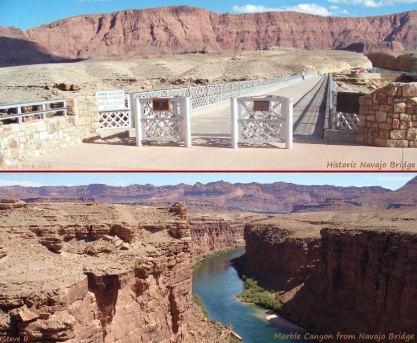
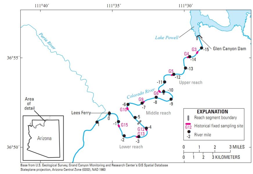
Navajo Bridge(s) is 17 miles downstream from the Glen Canyon Dam bridge. Lees Ferry was constructed in 1871, the only crossing of the Grand (eventually Colorado) River between the Moab ferry and Topock, Arizona/Needles, California, a distance of 800+ miles. The ferry capsized in 1928, drowning 3 men and dumping a Model T into the river. Since the Grand Canyon bridge (renamed Navajo bridge in 1934) over Marble Canyon was nearing comppletion, the ferry was not reopened. The sharp corners in the roadway on each side of the bridge's approach had become a safety hazard due to low visibility, and the deficiency in the design's width and load capacity specifications were becoming problematic. A new bridge was built beside the existing bridge, with the original become a pedestrian walkway providing an excellent view into Marble Canyon 467 feet below. At the same time, the Navajo Interpretive Center was built, providing a US89A rest area on the side of the canyon with access to the walkway.
Next, 342 miles downstream, on the other side of the Grand Canyon and Lake Mead, is Boulder Dam (renamed Hoover Dam in 1947), finished in 1935 (construction photo), which provided a Colorado River crossing for US 93 for 74 years until the bypass was built. Following 9/11, US 93 across the dam was closed to trucks and military checkpoints were positioned on each side of the dam, causing delays of three to fours hours on weekends. Mingling pedestrian with highway traffic on the dam had become a problem over the years with the increasing highway traffic. The Mike O'Callaghan-Pat Tillman Memorial Bridge, the US 93 Hoover Dam Bypass, was finished in 2010, providing a solution to both problems. In 2019, a new 22.8 mile (36.7 km) limited access highway bypassing Boulder City for US 93 & 95, connected to the bypass and became the initial segment of new Interstate 11.
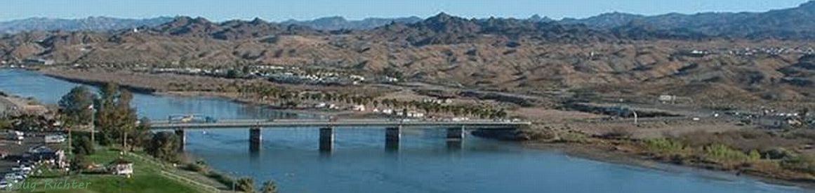
Now comes the Laughlin bridge, 68 miles downstream from Hoover Dam. In 1987, casino owner Don Laughlin built a bridge across the Colorado between Laughlin, Nevada, and Bullhead City, Arizona, at a cost of $3.5 million, to provide Arizona-access to his casino. He donated the bridge to the states of Nevada and Arizona.
Topock, Arizona (and Needles, California), the southwestern end of our story of the Colorado River bridges, is 40 miles downstream from the Laughlin Bridge.
This discussion includes the Needles ferry, the Red Rock bridge, the Old Trails bridge, and the I-40 bridge that is the end of the story.
The Needles ferry (established date unknown) was destroyed by flood in 1914.
This is our first meeting with the Red Rock bridge.
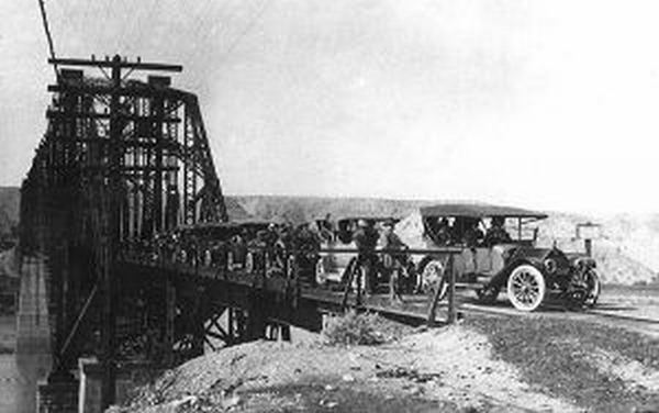
The Red Rock railroad bridge was built in 1890 by the Atlantic and Pacific railroad.
When the ferry was lost, planks were placed on the ties so autos could cross the bridge, and the railroad and highway shared the bridge until 1916 (photo).
In 1916 the Old Trails bridge was built for the Old Trails National Road.
Following the Federal Aid Highway Act of 1925, US 66 was created in 1926 when the national highway numbering system was created, and it crossed the Old Trails bridge.
It is a narrow bridge that allowed two-way traffic for autos but one-way for trucks.
That was not a problem until truck traffic increased during and after WW II.
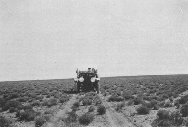
Trail
would be more correct than Road
- here is a 1915 photo of the Old Trails National Road near Holbrook, Arizona.
In 1945 the railroad (now the Santa Fe) built a new railroad bridge, replacing the Red Rock Bridge.
The Red Rock bridge was modified for highway traffic - a road bed was constructed - and US 66 was moved to it from the Old Trails bridge in 1947.
The Old Trails bridge was converted to carry a natural gas pipeline, which it continues to do today.
The Red Rock bridge carried US 66 from 1947 until the Interstate 40 bridge was built in 1966.
The Red Rock Bridge was dismantled in 1976.
This concludes the history section of the article, and we turn to a quick mileage recap, a listing of the bridges by date, some documentation data, and an errata.
The mileage recap:
It is 71 river miles from the CO 340 bridge - the old Fruita bridge - to the Dewey bridge;
it is 31 river miles from the Dewey bridge to the US 191 bridge at Moab, Utah.
It is 110 river miles from the bridge at Moab to the Bridge at Hite Crossing over the Colorado and Lake Powell (at normal levels).
It is 154 river miles from Hite Crossing to the Glen Canyon Dam Bridge,
and Navajo Bridge is 21 miles downstream from Glen Canyon Dam.
There is .3 mile between Hoover Dam and Hoover Dam Bypass, 342 miles downstream from Navajo Bridge.
It is 68 miles downstream from Hoover Dam to the Laughlin bridge,
and 40 river miles to the I-40 bridge that replaced the US 66 Topoc bridges in 1966.
That is a total of 833 river miles between the Fruita bridge and the I-40 bridge at Topoc, Arizona, and Needles, California.
Dates recap:
The Red Rock railroad bridge was buiilt in 1890 but did not carry road traffic until 1914-1916, and again from 1947 until 1966.
The Fruita bridge was built in 1907.
The Moab bridge was built in 1912, the current US 191 bridge was built in 2010.
The Dewey bridge was built in 1916, the current Dewey bridge was built in 1985.
The Old Trails bridge was built in 1916, still standing as a natural gas pipeline, the I-40 bridge was built in 1966.
Navajo bridge was built in 1929, still standing as a pedestrian walkway, the new bridge was bult by its side in 1995.
Hoover Dam served as a bridge for US 93 from 1936 until the bypass was built in 2010.
Glen Canyon Dam bridge was built in 1959, it still stands today as the US 89 bridge.
The Bidge at Hite Crossing was built in 1966 for UT 95.
The Laughlin bridge was built in 1987.
The USBR documents the lower Colorado River from the Gulf of California to Lee's Ferry, but not the Upper Colorado, so we use a USGS map, Benchmark Maps, Wikipedia, and the BLM for the Upper Colorado from the Paria to Fruita.
[Note that the NPS sites are not always reliable - they work sometimes, sometimes not.]
1906-7 Fruita bridge: Historical data at nps.gov, Preservation info at ColoradoPreservation.org.
1912 bridge at Moab: History at MoabHappenings.com (13th paragraph).
1916 Dewey bridge: historical info at Wikipedia in their article on Utah State Route 128.
1916 US66 Old Trails Bridge
at Topoc/Needles: history at NPS, Route 66 history at AzRt66.
1890 Red Rock railroad bridge: Mohave County Highways, the bridge that carried Route 66 between 1947 and 1970 when the I-40 bridge opened.
The river miles for the US66, Hoover Dam, and Navajo bridges come from the USBR rvmiles document (may not open in Chrome).
The river miles between Navajo and Glen Canyon Dam bridges come from a USGS map, supplemented by the USBR document.
The river miles in Utah come from Wikipedia and Benchmark Utah and Colorado maps.