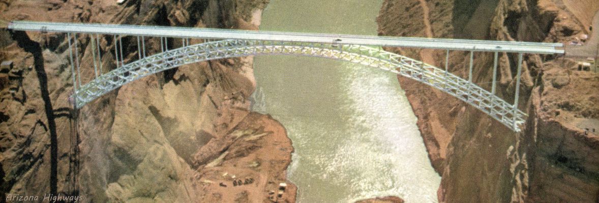
Glen Canyon Dam Bridge
The US Bureau of Reclamation - the agency charged with managing water in the West The Glen Canyon Dam Bridge was built by the USBR, and Page, AZ, established to service the building and maintenance of Glen Canyon Dam. There were no roads in this isolated area (note no pavement at either end of the bridge in the banner photo). When finished in 1959, at 700' it was the highest arch bridge in the world. US89 was rerouted over the bridge, and the original US89 over Navajo Bridge was renaned Alt US89 (US89A). It is interesting that Glen Canyon Dam is just as large as its companion Hoover Dam but gets little attention by tourists - perhaps because of its remote location, perhaps because Hoover Dam was such an innovative project in the 1930s.
But the dam does get a lot of attention from environmentalists who hold that Lake Powell should be drained in an attempt to reverse the downstream environmental effects of the dam. That is rather interesting, given that environmentalists are the ones who gave this location to the USBR to build the dam and create Lake Powell as an alternate location to damming Green River in Dinosaur National Monument near the Utah-Colorado border. The Sierra Club and its leader, David Brower, were instrumental in blocking the dam in Dinosaur, ignoring Glen Canyon in the process. Before Glen Canyon was flooded, but after winning the struggle in Congress, Brower floated the canyon and realized what a tremendous resource it was.
We understand the need to preserve such magnificent resources as Glen Canyon, but we also understand the need of flood control and water storage for the necessities of life in the arid desert. Even with the dam, in non-drought times we have Colorado River elevation changes of over 15', and we suffer long-term droughts (see Colorado Basin Drought on the Scenic Color Country home page menu; and the disappearance of Ancestral Puebloans in 1300 AD is blamed on a 23-24 year drought). Consider the damage of by a 15' flood through through Utah, Arizona, Nevada, California, and Mexico.
A massive controlled discharge in 2012, from the huge Rocky Mountain snowpack of winter 2011, rebuilt sandbars and restored ecosystem damage in the Grand Canyon. The Colorado River Basin remains in drought - Lake Mead set an all-time record - down 142+' (43+ m) on 20 May, 2015.
View Photos is an auto-show of the photos, and the Page Area Map includes many attractions in the area.