Goblin Valley State Park
Goblin Valley State Park is on the southeastern edge of the San Rafael Reef (see San Rafael Swell - the best kept secret in the west).
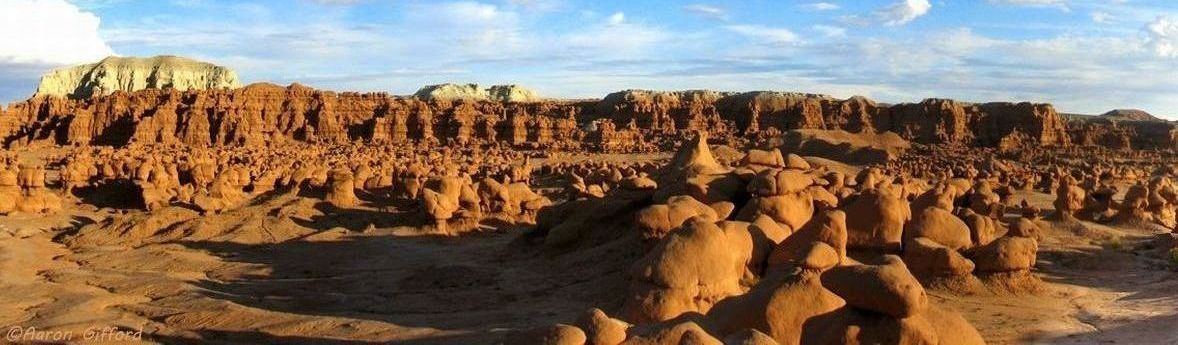
Its eminent feature is its thousands of hoodoos and hoodoo rocks, which are formations of mushroom-shaped rock pinnacles, some as high as several meters.
The distinct shape of these rocks comes from an erosion-resistant layer of rock atop softer sandstone.
[Wikipedia]
Evidence of Native American cultures, including the Fremont, Paiute, and Ute, is common throughout the Swell in the form of pictograph and petroglyph panels.
Goblin Valley is off U24, 39 miles south of I-70, 30 miles north of Hanksville.
Goblin Valley State Park is comprised of three valleys, side canyons, and the Goblin's Lair.
Most photos come from Valley 1, which is visible from the Observation Point; very few visitors go beyond Valley 1.
Valley 2 is a short, easy, hike: down the staircase into valley 1 and beyond the white dome.
Continuing on the Goblin Valley Trail, a moderate, uniproved, sparsely marked trail throughRed Canyon wash goes into Valley 3.
Goblin Square
is an area to the south outside the park.
Goblin Valley State Park is home to an expansive cavern with skylights and ceilings 70 feet high that only a handful of visitors have ever seen. Park rangers lead a 3-mile (round-trip) backcountry adventure to this hidden treasure beginning a 10:00am and 3:00pm on selected Saturdays. Named the Goblin's Lair by the park, it has also been called the Chamber of the Basilisk. It is an easy 2.3 mile hike around the eastern border of the park to the Lair.
On Juen 17, 2022, the Bureau of Land Management transfered 6,300 acres bordering the park on the west, tripleing the size of the park. This area contains slot canyons; campsites and trails will be established over time in the new area of the park. Some of the text amd some photos come from the Utah State Parks web site.
Geology is a 22-page the geology of goblin valley state park
by Mark Milligan of the Utah Geological Survey with a detailed discussion of the geology of Goblin Valley, including the geology of San Rafael Swell and the Henry Mountains.
The Brochure is the brochure published by the park, updated version including the expanded section of the park.
The Park Map is cut from the brochure and enlarged, showing the trails, and the biking trails in the expanded section of the park.
The Photo Gallery has photos of Goblin Valley State Park, including a panorama of goblins and an auto-show of the photos.