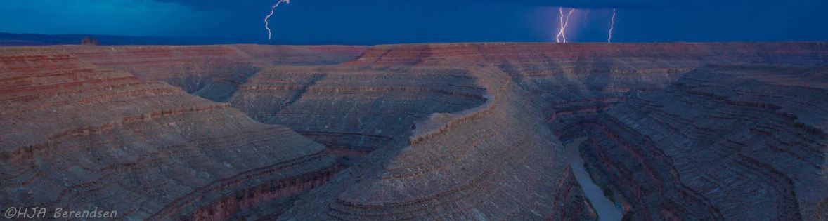
Goosenecks State Park
The San Juan River meandors for six and a half miles to travel one and a half linear miles inside Goosenecks State Park in south-eastern Utah. The park is at the end of Utah 316, a spur off Utah 261, which is a mile north of US163, near Mexican Hat, Utah. There is a $5 entry fee ($2/person commercial). It is primitive: no water (visitors must bring sufficient water), no electricity, minimal guard rails (you can walk right up to the edge - it's 1,000 feet to the bottom), fire pits, picnic tables, vault toilets, and primitive campsites.
From Wikipedia: Millions of years ago, the Monument Upwarp forced the river to carve incised meanders over 1,000 feet (300 m) deep as the surrounding landscape slowly rose in elevation.
Eroded by water, wind, frost, and gravity, this is truly a magnificent sight, and a classic location for observing incised meanders. . . .
The Honaker Trail is a hiking trail located near Goosenecks State Park in southeastern Utah.
Built in the late 1890s and early 1900s as a supply route for gold prospectors, the 2.5-mile (4.0 km) trail connects the deeply entrenched San Juan River with the canyon rim over 1,200 feet (370 m) above.
Popular with geologists, the trail serves as the type locality for the Pennsylvanian Honaker Trail Formation.
Fossilized crinoids and brachiopods, as well as trace fossils of other organisms are visible along portions of the trail.
The headwaters of the San Juan River are in the San Juan Mountains of southwestern Colorado, which is the origin of 90 percent of the river's flow. The San Juan flows 360 miles (579 km) from its source to the Colorado River, starting at an elevation of 14,000 feet (4,267 m) and dropping to 3,600 feet (1,097 m) at Lake Powell. The river is named for San Juan Bautista, Spanish for St. John the Baptist. Ancestors of today's Pueblo people lived in canyon tributaries of the San Juan, leaving behind images on stone, storage structures, and remnants of small masonry communities.
The San Juan runs through gorges and canyons on its course through Utah, past Bluff (the name tells all), cuts through Comb Ridge, through The Narrows as San Juan Canyon cuts through Raplee Ridge, crosses US163 at Mexican Hat, zigzaggs through Goosenecks State Park, and through more incised canyons until it reaches the Colorado at Lake Powell in Glen Canyon inside the Glen Canyon National Recreation Area.
The Honaker Trail was built in 1894 by Jack Honaker as a supply route for his gold prospecting in the late-1890s gold rush. The gold prospecting failed, but the trail remains as one of the few ways of reaching the floor of the San Juan some 1200' (370m) below the rim. The trail is used by hikers, geologists, and San Juan River rafters. Photos from the Honaker Trail are included in the gallery.
Select Photo Gallery to view photos of goosenecks of the San Juan inside and west of Goosenecks State Park, and an auto-show of the photos.
Park Map is a relief map of Goosenecks State Park.