Satire on a Parody of Names
Grand, Green, & Colorado Rivers and Grand, Marble, & Glen Canyons
Research on Grand, Green, and Colorado Rivers, and Grand, Marble, and Glen Canyons, can lead to much confusion, considering that National Park Service maps, Wikipedia, the U S Geological Society, Mapquest and Google Maps, and others, have confusing or disagreeing definitions and names. And a nearby settlement named Marble Canyon doesn't help any.
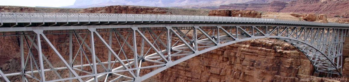
History tells us that the Grand Canyon Bridge was built in Marble Canyon, and that Navajo Bridge was built in Grand Canyon - the side-by-side bridges illustrated above. So, Marble Canyon, Glen Canyon, or Grand Canyon? And what river runs through it - Grand River, Green River, or Colorado River? All of this confusion led to my research, which clears up some - but not all - of the confusion, resulting in this article, which we call Satire on a Parody of Names. So, adding to the intrique, here is the real story (according to Dave).
First, the river now known as Colorado River. As currently defined, this 1,451 mileriver that drains 248,000 square miles in seven large western states, supplies water to 33 million residents, provides irrigation to the desert between the Rockies and its termination into the Gulf of California in Mexico, and to produce farms in southern California, is the largest waterway in southwestern United States. But it has not always been so.
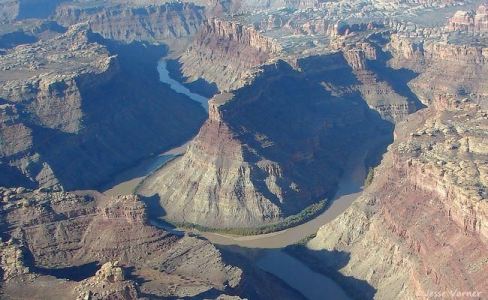
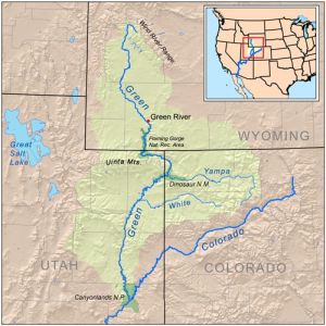
In river history prior to 1921, Grand River originates in La Poudre Pass Lake astride the continental divide in Rocky Mountain National Park in Grand County, Colorado, 16 miles north of Grand Lake - two of them - a city and a lake, both named Grand Lake. Grand River flows through Grand Lake (both of them), out of the Rocky Mountains and Grand County, Colorado, through Grand Valley and the city of Grand Junction, Colorado, and through Grand County, Utah, to its confluence with Green River in San Juan County, Utah. The USGS, with its policy of naming a river with the name of its longest tributary, considered it Green River from this point. [ Oh-oh! So, if they call it Green River instead of Grand River, does that mean they may consider it to be Green Canyon instead of Grand Canyon? ] An aerial view of the confluence of the Green and Colorado seems to confirm that Grand River flows into Green River in the middle of a horseshoe bend. And the Green's drainage basin is more than 70% greater than that of the Grand's. However, it was still known as Grand River until it reached Grand Canyon, whose eastern boundary at that time is the confluence of Grand and Little Colorado Rivers. This is the historical beginning of Colorado River - the confluence of Grand and Little Colorado Rivers at the eastern boundary of Grand Canyon (as it existed at that time - the national park was later expanded, more about that below).
Sound logical - Grand River flows into Grand Canyon, and becomes Colorado River at its confluence with Little Colorado River?
Apparently not to some unhappy Colorado cowboys, so the Colorado Legislature renamed Grand River to Colorado River inside the state of Colorado.
So now Colorado River flows to the Utah state line, where its name changes to Grand River, and flows to Grand Canyon (more precisely, the confluence with the Little Colorado), where once again its name changes to Colorado River.
Not satisfied, a Colorado US Representative, in a political ploy that attempted (unsuccessfully) to steal others' water rights, withstanding protests from the USGS and the states of Wyoming, Utah, and Arizona, had the name changed by the US Congress on July 25, 1921, to Colorado River for its entire length in the US to the Mexican border, creating orphans of Grand Lake and Grand Lake city, Grand Valley, Grand Junction, Grand Counties in Colorado and Utah, Grand Canyon Bridge, and Grand Canyon.
[Sidebar: Grand River ended at the beginning of Grand Canyon - the river flowing through the Grand Canyon has always been Colorado River.]
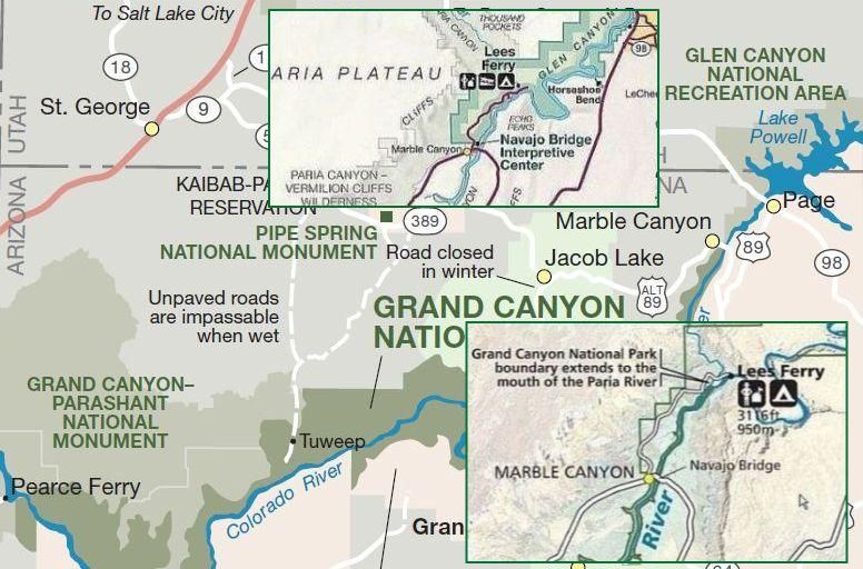
Now, the canyons. Marble Canyon National Monument boundary was Lees Ferry on the east, and the confluence of Grand|Green|Colorado and Little Colorado Rivers on the west, which was the eastern boundary of Grand Canyon. The western boundary of Grand Canyon is Pearce Ferry, the beginning of Lake Mead. NPS tells us that the eastern boundary of Grand Canyon was extended to Lees Ferry in 1975 (Really? see note at the end of the paragraph), eliminating Marble Canyon National Monument and Marble Canyon. Did it? The National Park Service no longer lists Marble Canyon National Monument, but search engines return over a million references to Marble Canyon, including many at NPS and USGS, and it is identified on all their maps. So, although the monument is gone, the canyon named Marble Canyon remains. [Note: although the NPS says the Grand Canyon ends at Lee's Ferry, a look at NPS' Grand Canyon maps (link below) shows that one map says it is Navajo Bridge, on another map it is at the confluence of the Paria, which is close to Lee's Ferry, but not precisely at it, giving us three definitions from NPS of the boundary.]
Glen Canyon brings more intrigue to the discussion. It begins at the Glen Canyon National Recreation Area eastern boundary and exists underneath Lake Powell for 186 miles to Glen Canyon Dam, continues 15 miles downstream as an open canyon, and ends at Lees Ferry, the beginning of Grand/Marble Canyon. Does it? NPS says it ends at Lees Ferry in the dialog, but their map (link below) shows the western boundary continuing on to Navajo Bridge, which is in Grand Canyon. And in Marble Canyon. And the Grand Canyon map agrees.
So the canyon between Lees Ferry, or the confluence of the Paria and the Colorado according to which reference is used, spanned by Navajo Bridge (formerly Grand Canyon bridge in Marble Canyon), has three official names: Grand Canyon, Marble Canyon, and Glen Canyon; and the Grand or Green River that flows through it is known as Colorado River. All of this can seem to be a little (or a lot?) confusing.
Hence this Satire on a Parody of Names.
Maps. The maps graphic provides an overlay of three NPS maps from various NPS sources: a map of Grand Canyon showing the Canyon ends at Navajo Bridge, an overlay cropped from another NPS map indicating the Grand Canyon boundary is at the confluence with the Paria, and another insert showing Glen Canyon National Recreation Area extends beyond Glen Canyon to Navajo Bridge in Marble Canyon (and Grand Canyon).
Debate, position 1: How is it that a US Representative from Colorado can have more influence than the United States Geological Survey and the states of Wyoming, Utah, and Arizona, on a river outside his jurisdiction but inside theirs, and, in the process, orphan Grand Canyon, Grand Canyon Bridge, Grand Valley, Grand Junction, Grand Lake, Grand Lake City, and Grand County in two states?
Debate, position 2: In the late 1800s, John Wesley Powell - explorer extraordinare after whom Lake Powell is named - named this magnificant geologic area known as the Colorado Plateau. The 1,451 mile river named Colorado pretty much (90%) drains the Colorado Plateau. In those days, no one knew - or had any idea - of the course and length of the river. But if they had, perhaps it would originally have been named Colorado River, or Green River if named by the USGS, and what is now known as Grand Canyon could instead be known as Colorado Canyon or Green Canyon? And while it may be that Green River provides 70% of the basin drainage, who says that its snowpack is greater than that of the rest of the Rockies?