Minute 319
“In the 21st century, there has been renewed interest in restoring a limited water flow to the [Colorado River] delta. In November 2012, the U.S. and Mexico reached an agreement, known as Minute 319, permitting Mexico storage of its water allotment in U.S. reservoirs during wet years, thus increasing the efficiency with which the water can be used. In addition to renovating irrigation canals in the Mexicali Valley to reduce leakage, this will make about 45,000 acre feet (56,000,000 m3) per year available for release to the delta on average. The water will be used to provide both an annual base flow and a spring "pulse flow" to mimic the river's original snowmelt-driven regime.
The first pulse flow, an eight-week release of 105,000 acre feet (130,000,000 m3), was initiated on March 21, 2014, with the aim of revitalising 2,350 acres (950 hectares) of wetland.
This pulse reached the sea on May 16, 2014, marking the first time in 16 years that any water from the Colorado flowed into the ocean, and was hailed as "an experiment of historic political and ecological significance" and a landmark in U.S.–Mexican cooperation in conservation.
The pulse will be followed by the steady release of 52,000 acre feet (64,000,000 m3) over the following three years, just a small fraction of its average flow before damming.
[Wikipedia]
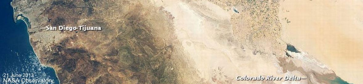
The Imperial and Coachella Valleys of southern California, and the corresponding Mexicali Valley and Colorado River Delta in Mexico, are part of the Salton Trough.
This large geologic structure, known to geologists as a graben or rift valley, extends into the Gulf of California.
The trough is a geologically complex zone formed by the interaction of the San Andreas transform fault system—which is, broadly speaking, moving southern California towards Alaska—and the northward motion of the Gulf of California segment of the East Pacific Rise, which continues to widen the Gulf of California by seafloor spreading.
[NASA Observatory]
Note that the Colorado cannot be seen in the banner image (it's completely dry).
In the NASA Observtory annotated original image in the gallery we can see where Colorado River dries up at the Imperial Dam north of Yuma, Arizona. The US/Mexican border runs from the north edge of Tijuana and Mexicali to Yuma, where it drops south of Yuma and to the south east to the Rio Grande at Ciudad Juarez and El Paso, where it follows the Rio Grande to the Gulf of Mexico.
The Salton Sea, visible in the original image (in the gallery), was formed in an engineering accident by the rupture of an irrigation canal in 1905 that allowed the Colorado River to flow into the Salton Trough. It is sustained by agricultural runoff water and three usually dry rivers and has no outlet. The toxic lake, in the low point of the Salton Trough rift and the largest in California, continues to sink (236.0 ft, 71.9 m below sea level as of January 2018) as California continues its tectonic move north. A photo of the Salton Sink portion of the Salton Trough [Rift] is in the gallery.
Minute 319 expired in 2017, select Minute 323 for the current agreement between the US and Mexico.
Select Photo gallery for photos of the Colorado River and its delta before and after the 2014 river pulse.