
Natural Bridges National Monument
Natural Bridge National Monument was created on April 16, 1908, by President Theodore Roosevelt - Utah's first National Monument (there are now nine, and five national parks).
There are three natural bridges in the monument, listed in order of their age: Sipapu, Kachina, and Owachomo - Hopi names.
Sipapu is translated as the opening between worlds,
Kachina was named for the dancers in petroglyphs at the base of the bridge thought to be named after a spirit being, and Owachomo means "rock mound," named for the rock formation on top of the east end of the bridge.
There is evidence of at least two collapsed natural bridges within the Monument.
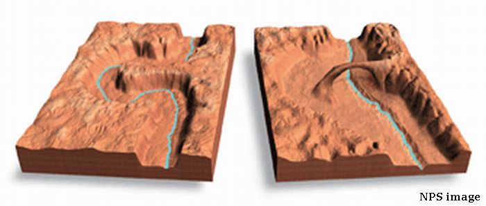
As indicated above, natural bridges are subject to collapse - approximately 4,000 tons of sandstone fell from the inside of the Kachina bridge opening in June 1992. We borrow from our Rainbow Bridge article the images showing how these bridges are formed over time by erosion caused by flowing water (mouse over the image for a larger version). The process is similar for the arches in Arches National Park except that it is salt left by the oceans that covered the area eons ago that is eroded, instead of limestone which is eroded for natural bridges. There is a neaby fault (the Moab fault in Arches NP) but the Colorado Plateau is pretty stable so while a shaking from a quake could cause damage/collapse to the bridges, it is a rare event on the plateau. Older, narrower Owachomo is more susceptible to such an event.
The monument is located at the end of Utah 275, 31 miles west on Scenic Byway 95 from US 191, south of Blanding, Utah. Inside the monument, U275 becomes Bridge View Drive, which winds along the park and goes by all three bridges, and by hiking trails leading down to the bases of the bridges. In the order that they appear along the drive, Sipapu Natural Bridge spans White Canyon, views to the northwest look through the bridge into White Canyon, Kachina Natural Bridge spans White Canyon at its junction with Armstrong Canyon, and Owachomo Natural Bridge is over Armstrong Canyon, a tributary to White Canyon. White Canyon begins in the foothills of the Abajo Mountains, passes through the monument, and runs alongside SB95 (or SB95 runs alongside the canyon) until it crosses under SB95 just before joining Glen Canyon and Lake Powell near Hite, Utah.
Horsecollar Ruin is an Ancestral Puebloan ruin visible from an overlook a short hike on a slickrock trail from Bridge View Drive (photos in the gallery). The ruin can be reached via an unmaintained trail between Sipapu and Kachina bridges in White Canyon (the trail is on the Monument map). The site was abandoned more than 700 years ago but is in a remarkable shape due to low humidity and little flowing water, including an undisturbed rectangular kiva with the original roof and interior, and two granaries with unusual oval shaped doors whose shape resembles horse collars.
The Photo Galley contains multiple photos of the bridges from differing view points and a photo of the Horsecollar Ruin and an auto-show of the photos.
The bridge erosion graphic comes from our Ranbow Bridge article, photos of White Canyon are in the White Canyon (Utah) article.